Digital Mapping Tools Aid Venezuelan Disaster Response Amid Seismic Activity
Crowdsourced digital mapping platforms are providing the Venezuelan diaspora with real-time infrastructure updates following recent seismic activity, though officials warn these unofficial reports should be used only as a supplement to verified data.
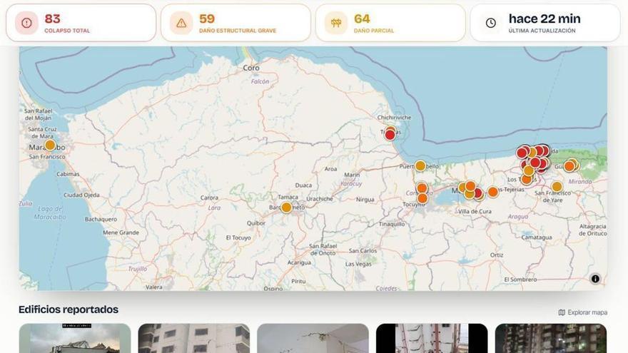
Collaborative digital mapping platforms have become essential tools following recent seismic activity in Venezuela. These platforms allow citizens to report the status of local infrastructure in real time, providing a vital resource for people abroad trying to understand the impact of the disaster on their home communities.
The system works by using voluntary reports to categorize buildings based on their physical condition—ranging from total collapse to significant structural failure or minor damage. This visual map helps users quickly see how damage is distributed across the region. For the Venezuelan diaspora, particularly those in Spain and the Canary Islands, these updates have become a primary way to monitor the safety of their loved ones.
However, it is important to use these tools with caution. Because the maps rely entirely on reports from the public, the information can change quickly and is not considered an official source. These records lack the technical verification provided by rescue teams and structural engineers on the ground. While these platforms offer a helpful overview of the situation, they should be used only as a supplement to official reports. Only assessments from competent authorities can provide the accuracy and safety required to fully understand the extent of the damage.